The History of
Paricutín Volcano
Born in a farmer’s cornfield on a winter afternoon in 1943, Paricutín became one of the most closely observed volcanic events in recorded history — and forever changed the landscape of western Mexico.
- First Eruption
- Feb 20, 1943
- Last Activity
- Mar 4, 1952
- Cone Height
- 424 m
- Lava Covered
- 25 km²
- Elevation
- 3,170 m asl
- Duration
- 9 years
A Volcano Born Before Human Eyes
On the afternoon of February 20, 1943, a farmer named Dionisio Pulido was working his cornfield near the small indigenous village of Paricutín, in the western Mexican state of Michoacán. He noticed a crack in the earth that had been there for some time, but on that particular afternoon the ground began to tremble, a smell of sulfur filled the air, and thin wisps of smoke started rising from the fissure. By nightfall, burning cinders and glowing rocks were being hurled into the sky.
What Pulido had stumbled upon was the birth of a new volcano — an event so rare that scientists consider it one of the most extraordinary geological occurrences ever witnessed by human beings. Within twenty-four hours, the mound of ejected material had grown several meters high. Within a week, it stood roughly 50 meters above the surrounding plain.
“I then felt a thunder, the trees trembled, and it was then I saw how, in the hole, the ground swelled and raised itself two or three meters high.”
— Dionisio Pulido, eyewitness account, 1943
Pulido, his wife Paula, and their neighbor Gil Ortiz are the named witnesses to the volcano’s first moments of life. Their account was recorded by scientists who arrived within days. Pulido reportedly attempted to smother the smoking fissure with soil before realizing the scale of what was happening. He never farmed that field again.
Rapid Growth and Escalating Eruptions
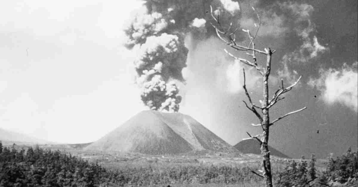
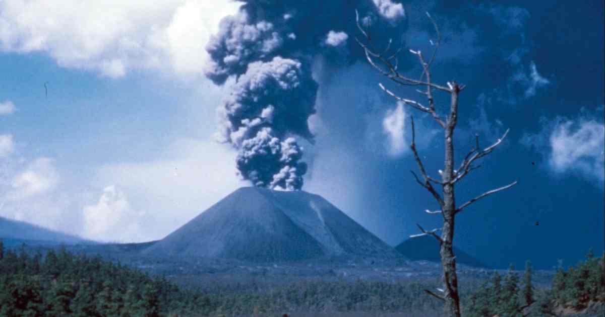
Paricutín grew with astonishing speed. During the first weeks, the eruption was intensely explosive, sending columns of ash, lapilli, and volcanic bombs thousands of meters into the sky. The noise could be heard from towns many kilometers away, and the glow of the crater was visible across the Michoacán highlands at night.
By the end of its first year, the cinder cone had reached approximately 336 meters above the original field level. At its greatest height, the summit of the cone stood around 424 meters above its base — making it one of the tallest cinder cones ever documented during active growth. The volcano sat at an elevation of roughly 3,170 meters above sea level.
As the explosive phase continued, lava flows began spilling from the base of the cone. These viscous rivers of molten basalt moved slowly but relentlessly across the surrounding farmland and forests, covering an area that would eventually reach approximately 25 square kilometers. The landscape of the Michoacán plateau was being permanently rewritten.
The Burial of Two Towns
As the lava flows expanded outward from the growing cone, two communities found themselves directly in their path. The village of Paricutín — the settlement that gave the volcano its name — was the first to be evacuated and ultimately buried beneath ash and lava. Its approximately 700 inhabitants relocated to a new settlement several kilometers away.
The larger and more significant loss was the town of San Juan Parangaricutiro, a historic Purépecha community with a colonial-era church that had stood for centuries. As the lava advanced through 1944, the roughly 8,000 residents were evacuated and resettled in a new location, which they named San Juan Nuevo Parangaricutiro. The old town was slowly engulfed.
Remarkably, no deaths were caused directly by the lava flows themselves. The movements were slow enough for complete evacuations to be carried out. Three deaths were recorded during the entire nine-year eruption, all caused by lightning strikes generated by the volcanic electrical storms — a common but dangerous byproduct of large ash columns.
What remained of San Juan Parangaricutiro after the lava hardened was haunting: the stone tower and portions of the facade of the old parish church protruded from the frozen black lava field, preserved in the act of being swallowed. Those ruins stand to this day and have become one of the most visited and photographed geological landmarks in all of Mexico.
Scientific Observation and Global Significance
From the moment of its birth, Paricutín attracted scientists from around the world. Volcanologists, geologists, and geographers converged on Michoacán to study the eruption in real time. Because the volcano appeared in an era of modern science and was geographically accessible, it offered something unprecedented: a complete, observable record of a volcanic life cycle from beginning to end.
Researchers documented the successive stages of cone formation, the composition and behavior of lava flows, the acoustic and seismic signatures of eruptive episodes, and the gradual transformation of the surrounding landscape. The data gathered at Paricutín informed generations of volcanological study and helped establish many of the baseline models used to understand cinder cone development.
Paricutín is classified as a monogenetic volcano — a type that erupts from a single vent during a single eruptive episode and then goes permanently dormant. This distinguishes it from stratovolcanoes and shield volcanoes, which can erupt repeatedly over tens of thousands of years. The entire lifespan of a monogenetic volcano like Paricutín is typically measured in years or decades, making the nine-year eruption relatively long for its type.
The volcano is located within the Michoacán–Guanajuato Volcanic Field, one of the largest and most active monogenetic volcanic fields on Earth, containing over 1,400 individual volcanic vents. The appearance of Paricutín was therefore not entirely surprising to geologists familiar with the region — but the fact that humans were present to witness it from the very first moment remains extraordinary.
The End of the Eruption and What Was Left Behind
Volcanic activity at Paricutín decreased steadily through the late 1940s and early 1950s. The explosive phase subsided first, giving way to quieter effusive flows. By early 1952, the eruption had reduced to a few scattered steam vents and minor lava seeps. On March 4, 1952 — nine years and twelve days after its birth — the eruption ceased entirely. Paricutín fell silent.
What remained was a stark and alien terrain. The cone itself, dark and steep, rose above a vast field of hardened black lava known locally as a malpais — a “badland.” Beneath that lava lay the fields, the forests, and the streets of two communities that had simply ceased to exist as living places.
In the decades that followed, life returned slowly. Pioneer plant species began colonizing the cooled lava. Insects, birds, and small mammals recolonized the margins of the flow. By the early twenty-first century, substantial vegetation had grown back across significant portions of the affected area, offering ecologists a natural laboratory for studying post-volcanic succession — how ecosystems rebuild themselves after total destruction.
Paricutín Today: Memory, Tourism, and the Living Landscape
Today, Paricutín is accessible to visitors from the town of Angahuan, a Purépecha community whose residents serve as guides and provide horses for the crossing of the lava field. The trek to the crater rim is demanding — several hours on foot or horseback across broken, uneven volcanic rock — but it rewards visitors with one of the most dramatic and lonely landscapes in North America.
The ruins of the church of San Juan Parangaricutiro remain the most evocative sight on the route: a colonial bell tower rising from black stone, the surrounding lava frozen in motion, the silence broken only by wind. For the Purépecha people of the region, the church ruins are not merely a tourist attraction but a place of pilgrimage and memory — a monument to a town that was swallowed, and a people who survived.
Paricutín is also recognized as one of the Seven Natural Wonders of the World as listed by CNN, alongside landmarks such as the Grand Canyon and the Northern Lights. It remains the only volcano in recorded history to have been observed from birth to extinction, a distinction that ensures its continued importance in the history of Earth science.
Questions & Answers About Paricutín
When and where did Paricutín Volcano first appear?
Paricutín first appeared on February 20, 1943, in a cornfield owned by farmer Dionisio Pulido near the village of Paricutín in the state of Michoacán, Mexico. It is one of the very few volcanoes in recorded history whose birth was directly witnessed by human beings, making it uniquely significant in the annals of geological observation.
Who witnessed the birth of Paricutín Volcano?
The birth of Paricutín was witnessed by local Purépecha farmer Dionisio Pulido, his wife Paula, and a neighbor named Gil Ortiz. Pulido described hearing a deep rumbling like thunder and feeling the ground heave beneath his feet before smoke and ash began rising from a fissure in his field. His account was later recorded in detail by scientists who arrived within days of the eruption’s start.
How tall did Paricutín Volcano grow?
Within the first week of its eruption, Paricutín had already grown to approximately 50 meters tall. By the end of its first year, the cone reached about 336 meters above the surrounding plain. At its maximum, the volcano stood roughly 424 meters above its base — or approximately 3,170 meters above sea level — placing it among the tallest cinder cones ever observed in active growth.
How long did Paricutín Volcano erupt?
Paricutín erupted continuously for nine years, from February 20, 1943, until March 4, 1952. During this period it ejected an estimated one billion tons of volcanic material — ash, cinders, lava bombs, and lava flows — permanently transforming approximately 25 square kilometers of the Michoacán highlands.
What towns were destroyed by Paricutín?
Two towns were buried by lava flows and volcanic ash: the village of Paricutín itself, and the larger Purépecha town of San Juan Parangaricutiro. In both cases the inhabitants were successfully evacuated before the lava arrived. No deaths were directly caused by the lava flows. Three people died during the eruption’s nine-year span, all from lightning strikes generated by the volcano’s electrical storms.
What remains visible of San Juan Parangaricutiro today?
The stone bell tower and portions of the facade of the old colonial parish church still protrude from the hardened lava field. The lava surrounded and partially buried the structure but left the tower standing. These ruins have become one of the most iconic and photographed geological landmarks in Mexico, and remain a place of active pilgrimage for the Purépecha community.
What type of volcano is Paricutín?
Paricutín is a cinder cone volcano — the most common type of volcanic landform on Earth. Cinder cones are built primarily from the accumulation of tephra: fragments of solidified lava blown out during explosive eruptions. They are typically monogenetic, meaning they erupt from a single vent during a single episode and do not erupt again. Paricutín fits this profile exactly.
Why is Paricutín scientifically important?
Paricutín is one of the few volcanoes in history whose complete life cycle — from birth to final extinction — was observed and systematically documented by scientists. The data gathered during its nine-year eruption became foundational to our understanding of cinder cone formation, lava flow dynamics, and the long-term ecological recovery of volcanic landscapes. It remains a textbook reference for volcanology students worldwide.
Is Paricutín Volcano still active?
Paricutín is considered dormant and is not expected to erupt again from the same vent. As a monogenetic volcano, it had one eruptive episode and has been quiet since March 4, 1952. However, the broader Michoacán–Guanajuato Volcanic Field in which it is located remains one of the most volcanically active regions in Mexico, and future eruptions elsewhere in the field are considered a geological certainty over long timescales.
Can visitors hike to the summit of Paricutín today?
Yes. Visitors access the volcano from the town of Angahuan, approximately 35 kilometers northwest of the city of Uruapan. Local Purépecha guides lead tours on foot or horseback across the hardened lava field to the church ruins and, for those wishing to continue, up to the crater rim. The full ascent and return takes most of a day. The terrain is rugged and the altitude significant, so visitors are advised to prepare accordingly.
What is the connection between Paricutín and the Purépecha people?
The land around Paricutín has been home to the Purépecha — an indigenous people with a distinct language and culture — for centuries. Both of the towns destroyed by the volcano, Paricutín and San Juan Parangaricutiro, were Purépecha communities. The town of Angahuan, from which most visitors today begin their journey to the volcano, is also Purépecha. The community has played a central role in preserving the memory of the eruption, maintaining access to the site, and honoring the ruins of the buried church as a place of cultural and spiritual significance.