Paricutín Volcano
Today
More than seventy years after its last eruption, Paricutín stands open, accessible, and unchanged in its geological drama — a landscape unlike anything else in the Americas.
What Paricutín Looks Like Right Now
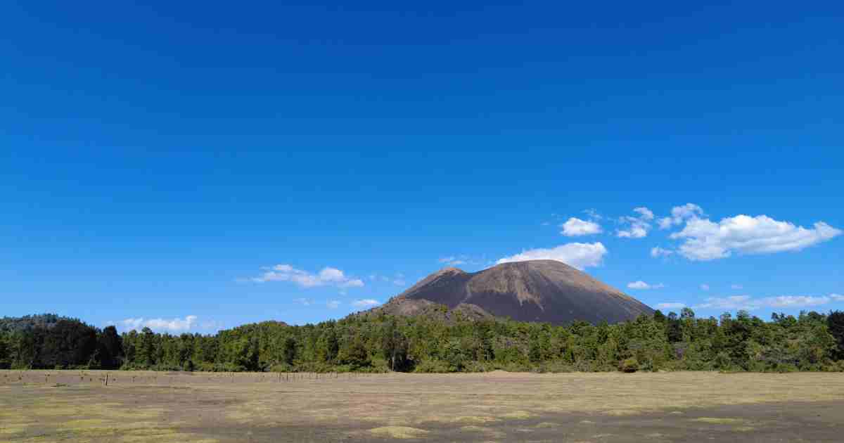
Standing at the edge of Paricutín’s lava field today, a visitor sees something that has changed very little since the eruption ended in 1952. Roughly 25 square kilometres of hardened black basaltic lava still stretch across what was once a landscape of farmland, pine forest, and two inhabited villages. The cone itself rises above the plain — grey-brown, sharp-edged, and still dusted with loose volcanic ash and cinder at its upper slopes. The crater at the summit is open, cool, and completely silent.
The most striking man-made landmark within this landscape is the bell tower and apse of the 16th-century church of San Juan Parangaricutiro, which protrudes from the frozen lava approximately five kilometres from the base of the cone. The surrounding village was buried by lava in 1944 and never rebuilt. The church wall and tower remain in place exactly as the lava left them — a fixed point in an otherwise featureless black plain, well-preserved by the dry highland climate.
The cone itself has eroded modestly since 1952. Wind and rain have carved shallow gullies into its upper ash slopes, and the crater rim is slightly lower and more rounded than it was immediately after the eruption. The overall shape, however, remains the classic steep-sided cinder cone profile that formed during nine years of continuous eruption. The horizon from the summit stretches across the entire Michoacán highlands, and on clear days reaches beyond the volcanic chain toward distant peaks.
How the Land Has Changed — and How Much Has Not
Seven decades of weathering, rainfall, wind erosion, and biological colonization have begun to soften the edges of the Paricutín lava field — but only at its margins. At the outer reaches of the lava flow, where the basalt has fractured and accumulated enough wind-blown ash to form a thin soil layer, mosses, ferns, and pioneer tree species have taken root. These early colonizers are the first stage of what ecologists call primary succession — the slow process by which living systems reclaim a landscape stripped bare by volcanic activity.
Moving toward the centre of the lava field, however, this recovery disappears. The central zone remains a raw, unweathered terrain of black and rust-coloured basalt, broken into jagged slabs and loose rubble. Nothing lives there in any significant concentration. The surface is hot in midday sun, sharp underfoot, and largely unchanged from the day the lava cooled. Volcanologists and ecologists who study long-term lava field succession estimate that full forest recovery of the central zone will take several hundred years at minimum.
The cone itself has undergone gradual erosion since 1952. Rainfall has carved small gullies into the upper ash layers, and wind has redistributed some of the loose cinder. But the basic form — a steep, symmetrical cinder cone rising sharply above the surrounding plain — remains clear and largely intact. It is, in geological terms, an extremely young landform. The 70-plus years since its formation represent a fraction of a second in the timeline of volcanic erosion.
“The lava fields of Paricutín are among the youngest geological surfaces accessible to ordinary visitors anywhere on Earth. Walking across them is as close as most people will ever come to standing on newly made land.”
Angahuan Today — The People Who Manage the Site
The village of Angahuan, a Purépecha indigenous community, sits on the edge of the lava field and controls all visitor access to Paricutín Volcano. There is no federal park administration at the site. The community of Angahuan has managed the tourism operation independently, setting its own fees, training its own guides, and maintaining its own horse rental operations. Every peso of entrance fees, guide fees, and horse rental income goes directly into the community economy.
Angahuan itself is worth arriving for before the hike begins. The village has an exceptional 16th-century open chapel — the Templo de Santiago Apóstol — whose carved facade is considered one of the finest examples of Plateresque stonework in Michoacán. The Purépecha people of the region have lived in these highlands for centuries, and their culture, language, and crafts remain active and visible in the village.
The displaced descendants of the two buried villages — Paricutín and San Juan Parangaricutiro — were resettled in a new town called San Juan Nuevo Parangaricutiro, built a few kilometres from the lava zone. That town remains active today and is sometimes visited as part of a broader Paricutín trip. It maintains the community’s connection to its buried ancestral home, and local craftwork and cultural traditions from before the eruption continue to be practised there.
What Researchers Are Still Learning from Paricutín
Paricutín’s scientific value did not end when the eruption stopped in 1952. Today the site continues to be studied across multiple disciplines, and it remains one of the most important long-term reference points in volcanology, ecology, and geological history.
In ecology, Paricutín is an invaluable living laboratory for the study of primary succession — the process by which ecosystems rebuild themselves from nothing on a barren volcanic surface. Researchers from Mexican and international universities have monitored plant and animal colonization of the lava field since the 1950s, tracking which species arrive first, in what sequence, and at what rates. The progression from bare basalt to pioneer moss to early shrub cover to eventual forest represents one of the most thoroughly documented examples of ecological recovery after a volcanic event anywhere in the world.
In volcanology, Paricutín remains the gold standard reference for cinder cone development, lava flow dynamics, and the natural erosion of a monogenetic volcanic landform over time. Because the entire eruption was observed and documented, scientists have a precise baseline against which to measure every subsequent change. The cone’s erosion rate, the compaction of its ash layers, and the chemical weathering of its basaltic lava are all ongoing subjects of study.
The Smithsonian Institution’s Global Volcanism Program continues to maintain an active record of Paricutín’s dormant status, and the broader Michoacán–Guanajuato Volcanic Field in which it sits is monitored continuously by CENAPRED for signs of new volcanic activity unrelated to the Paricutín vent.
How to Visit Paricutín Volcano — A Step-by-Step Guide
Visiting Paricutín today is a well-established, clearly organised experience managed by the Purépecha community of Angahuan. The entry point, pricing structure, and route are consistent and straightforward. What the visit requires is time, physical preparation, and an early start. The full day — from Angahuan to the crater rim and back — takes between six and eight hours, not counting the journey from Uruapan.
-
Get to Angahuan from Uruapan
Uruapan is the base city for visiting Paricutín — it has hotels, restaurants, banks, and transport links including a domestic airport. From Uruapan’s central bus terminal, local buses run to Angahuan in 30 to 45 minutes. Taxis and arranged vehicles are also available. Depart by 7:00 am for the best conditions on the trail. Later starts risk being caught by afternoon weather, especially during the rainy season.
-
Pay the entrance fee and hire a local guide
At the Angahuan community entrance, pay the access fee and hire a local Purépecha guide. The guide is not legally mandatory but is essential in practice — the lava field trails are unmarked and disorienting, and a guide manages the horse rental and ensures you take the correct route to the cone and the buried church. The guide fee supports the community economy directly. Guides are experienced, patient, and accustomed to visitors of all fitness levels.
-
Cross the lava field by horse
Rent a horse for the crossing from Angahuan through the basaltic lava field. This section covers several kilometres of rough, uneven terrain — walking is possible but draining, and most visitors ride to conserve energy for the crater ascent on foot. The horse rental includes a handler who accompanies you across the field and waits at base camp during the summit climb. The ride itself is a dramatic experience — the black lava stretching in every direction, with the cone growing steadily ahead.
-
Visit the buried church of San Juan Parangaricutiro
Midway through the lava crossing, your guide will stop at the ruins of the old church. The bell tower and rear apse stand intact above a frozen sea of black lava — one of the most extraordinary and strange sights in all of Mexico. You can walk through the open apse, examine the original colonial stonework, and stand at the point where lava meets century-old masonry. Allow 20 to 30 minutes here. This stop gives the entire eruption — and the enormity of what Paricutín buried — its most immediate human scale.
-
Climb the cinder cone to the crater rim
From the base camp, leave the horses and begin the foot ascent up the steep ash and cinder slope. The surface is loose — each step forward involves a partial slide back, and the gradient is demanding throughout. Pace steadily, rest as needed, and take in the expanding view behind you as you climb. The ascent takes between 45 and 90 minutes depending on fitness and altitude tolerance. The summit sits at 3,170 metres above sea level. From the crater rim, the full panorama of Michoacán unfolds in every direction, and the crater bowl opens below — grey, still, and completely quiet.
-
Descend and return to Angahuan before dark
The descent of the ash slope is faster but requires careful footing — lean back slightly and take short, controlled steps. Return to base camp, remount your horse, and ride back across the lava fields to Angahuan. Tip your guide at the end of the day. Most visits conclude by 3:00 or 4:00 pm if started early. Plan transport back to Uruapan in advance — buses and taxis should be arranged for the late afternoon.
Clothing
- Ankle-support hiking boots
- Warm fleece or mid-layer
- Windproof outer jacket
- Long trousers or convertible pants
- Wide-brimmed hat or cap
- UV sunglasses
- Dust mask or bandana
Supplies
- 2–3 litres of water per person
- Packed lunch and snacks
- Sunscreen SPF 50+
- First aid kit and blister plasters
- Camera or charged smartphone
- Small backpack
- Cash in Mexican pesos
What Visitors Ask About Paricutín Volcano Today
The questions below are the most commonly asked by first-time visitors and travellers planning a current trip. Tap any question to expand the answer.

